Dogs Unknown

E-Bikes
Unknown
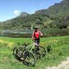
Overview
Though the ride starts with pavement, don't be fooled into thinking this ride will be easy! A fast downhill keeps things exciting and a technical climb finishes off the loop.
Description
You can leave the car in the town of Tocaima, and start your ride from there.
The ride will begin with pavement, before riders turn right and pass through some farms. You'll make your way off the paved road, and onto a long section of dirt road, where you won't have to worry about cars. Continue on the dirt road, and cruise down a big hill until you reach the highway again.
You'll stay on the highway as it winds to the town of Tobia. Once in town, you can stop at Paso del Rejo, and cool off in the cool water. If you're up for it, you can even take a dip!
Once you've made it through Tobia, keep an eye out for a section of singletrack trail on the right. Like much of the riding in this area, the trail here is technical singletrack, which requires both skill and stamina. You'll spend most of your time climbing through cane crops, and the two climbs are both steep and sustained. Bring plenty of water, as you'll want it on the flat sections! You'll finish off the loop with a technical singletrack climb back to your car.
Contacts
Shared By:
Jorge A Idarraga

 Continue with onX Maps
 Continue with Facebook


 Difficult

 4.5 (2)


0 Comments