Dogs Unknown

E-Bikes
Unknown

Avoid during rainy season. Clay.
Description
One of the iconic Menagesha singletrack descents that includes all land use types in the area from native juniper forest to pine to eucalyptus forest to lush agricultural land to degraded agricultural land.
Trail quality is superb and has a bit of everything: twisties, steeps, short slick rock sections, semi-technical undulations, one punchy short climb, long flowy fast sections, rock gardens, eucalyptus forest, and a long cruise through agricultural land and villages with a nice big field of rock in the middle to keep you honest. This is a 30-45 minute descent for fast/intermediate riders.
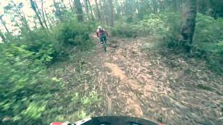
This video clip shows the
highlights of the trail.
It's best suited for a trail or enduro bike as there are some undulations, but it's mostly fast. One of the best descents I have ridden anywhere in the world.
Like all trails in Menagesha, there are too many intersections to keep track of. Follow the drainage down. Think like a cow heading down to market, and you'll probably stay on the right track. There are a few tricky turns though so use the GPS and do not go straight down to the creeks; stay up in the drainage.
Access: This trail starts at the main dirt road (Menagesha Suba Forest Rd) just below Emperor Menelick's hunting lodge, above Camp 3. A new unsigned dirt road as been built that turns off of Menagesha-Suba Rd, and this is where the ride starts (It was a trail last year but is now a short dirt road).
Shared By:
stephen danyo

 Continue with onX Maps
 Continue with Facebook


 Intermediate


0 Comments