The southernmost trail of the Saint Joseph system, this is a combination of old CCC footpaths from the 1930's and newer singletrack. This can cause some confusion for riders unfamiliar with the trail. Adding to the confusion are two large fields and portions of the area's cyclocross track that intersect the MTB trail. Branches block MOST confusing intersections.
This is a beginner level trail. It's all hardpack except where it crosses fields. There are few rocks, more roots. The trail isn't as hard, or as steep, as
Krug Park but is a bit more challenging than the
Girl Scout Trail. The
Brownie Trail has more of a technical challenge than this trail. And
Corby North can be combined easily with this to make
The Corby Combo. Girl Scout and Brownie are a very short ride away via the paved Urban Trail system for some more mileage.
The trailhead is to the east of the parking area and is marked by a brown wooden post that is easily seen as one approaches it.
At about the half mile mark, one enters the first field. TURN LEFT, following the edge of the field uphill and then back down toward reentry into the trees. Ignore the trail intersections and stay straight, eventually returning to open field again. Go straight, again following the edge of the field. You'll quickly return to the trees.
Just after the one-mile mark, the trail again intersects the cyclocross track. Ignore it! Again, keeping straight! Cross a small banked bridge in a right turn, you'll climb a little and enter the next field. You'll head fairly straight along the right side to the re-entry point into the trees on your right. IMMEDIATELY, upon reentry, you'll see the cyclocross bridge (you probably saw it already) BUT TURN LEFT!
Around 1.84 miles, the trail BARELY gets back into the field and isn't confusing.
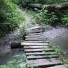
After crossing the railed bridge near 2.25 miles, you'll emerge near the street. Turn right for a quick reentry. Right after the drainage crossing, the MTB trail goes uphill. Take the wider path with the wooden waterbreaks. You're more likely to come upon walkers or people fishing on this next bit as the trail skirts along the bank of Corby Pond.
As the trail leaves the pond and goes uphill, KEEP STRAIGHT UP THE HILL ignoring the paths to the left. A little bit of rock on some fast downhill signals that you near the end. You'll see the parking area as you approach it. The MTB trail heads back toward the water and ends to the west of the parking lot.

 Continue with onX Maps
 Continue with Facebook


 Intermediate

 4.7 (3)


1 Comment