Dogs Leashed

E-Bikes
Not Allowed
Features
Drops/Jumps
Overview
Meadowood is a hidden gem nestled on Virginia's Mason Neck, a peninsula on the Potomac River rich in natural and cultural resources. The Neck is comprised almost entirely of public land, making it a great playground for riders, hikers, paddlers and history buffs of all ages. Combine a ride at Meadowood with a visit to historic Gunston Hall, or a paddle up Kane Creek from Mason Neck State Park at the tip of the peninsula for an all-day outdoor adventure.
The mountain bike trails at Meadowood wind their way through some of the best mature hardwood forest on the Mason Neck peninsula. Woody plants common to the woodlands, forests and forest edges at Meadowood include red and white oak, beech, sweet gum, Virginia pine, even persimmon and paw paws! The trails at Meadowood pass through a wide variety of terrain and vegetation types, providing riders with constantly changing seasonal experiences.
For more information about Meadowood call (703) 339-8009 or visit:
blm.gov/office/northeastern…
Portions of the
South Branch Loop form a segment of the Potomac Heritage National Scenic Trail, and the Washington-Rochambeau Route historic trail, and work is underway to connect Meadowood via the Potomac Heritage Trail to
Laurel Hill, the Cross County trail, and ultimately,
Fountainhead Regional Park! For advocacy updates and ways to get involved, check with MORE at
more-mtb.org.
Need to Know
You can begin this ride from any of the three trailheads at Meadowood. For big groups/multiple cars, parking at the large Mason Neck Gateway lot on Gunston
Road will be your best bet. If you have a smaller group, parking at Belmont Boulevard will let you start your ride with a rip down the
Belmont Connector downhill.
While the more technical trails on the interior of the loop are bike-specific, riders share
South Branch Loop with hikers and trail runners, and this trail crosses Meadowood's equestrian trails in several places. Please be courteous and ride under control when you come to these well-signed intersections and shared trails.
Description
Starting from the new Mason Neck Gateway parking area, head down the
Gunston Road Connector trail from the kiosk to the
South Branch Loop and turn right, taking the trail counterclockwise. You'll ride rolling singletrack through mature hardwood forests, crossing a Dominion Power gas line, before reaching your first intersection. Bear left to continue on
South Branch Loop.From here, turning right will put you on the
Old Colchester Connector and a small parking area.
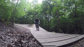
Climb the hill from the intersection, passing the exit to
Boss Trail. Just after you crest the hill, you'll see the entrance to
Boss Trail. Turn left and up onto the boardwalk that starts Boss and hang on for a good time!
Once you climb the hill at the end of
Boss Trail back to
South Branch Loop, head left to continue counterclockwise on the loop. Ride past the entrance to
Boss Trail and cross the old fire road to start the longest sustained downhill of the ride, dropping from this high point to
South Branch Loop's stream valley. This downhill is fast, tight, and fun. However, it's also open to two-way traffic, so yield to those poor folks slogging up the climb! 3/4 of the way down, you'll cross the equestrian trails via a gravel and rock-armored intersection, give a friendly shout or bell ring and be prepared to yield to horse traffic.
The downhill empties out onto the boardwalk crossing
South Branch Loop. From there you begin a series of short climbs and rolling singletrack. The boardwalk comes equipped with benches, and is a great spot for a food stop. You'll pass the exit of
Yard Sale Trail and climb a series of bermed turns, before passing the exit of
Stinger Trail and topping out on a bluff over the stream valley marked with a stone cairn. The entrance to
Stinger Trail is just around the corner.
Turn left onto the
Stinger Trail and enjoy the tight, bench cut singletrack, a series of short descents and climbs bring you back to
South Branch Loop below the bermed climb. Turn left to continue counterclockwise and pass the exit to
Stinger Trail this time. You'll cross the fire road and a small stream before reaching the entrance to
Yard Sale Trail.
Turn left off of
South Branch Loop to start your run down
Yard Sale. You'll run into
South Branch Loop just after the boardwalk over the stream valley, head left at the intersection, climbing past both
Stinger Trail and
Yard Sale Trail to continue your lap on
South Branch Loop.
After clearing the large, armored stream crossing, you'll hit a three-way intersection. Turn right for an optional out-and-back on the
Belmont Connector. This trail accesses the Belmont Boulevard trailhead, and is a leg buster of a climb, but a fun descent back to
South Branch Loop. It's definitely worth the extra few minutes.
Back on
South Branch Loop you'll cross the gas line cut again on a paved stone causeway, and have roughly a mile to go to get back to the intersection with the
Gunston Road Connector. Turn right to head back to your car at the Mason Neck Gateway lot, or head left to start a second lap on
South Branch Loop!
While this route is the most efficient way to hit all of Meadowood's trails on one trip around the loop, it's only an introduction to the system.
South Branch Loop flows great in both directions, and riders often session the three bike-specific trails and the
Belmont Connector multiple times before continuing on their way. While not the most physically demanding trail out there, Meadowood's smiles to miles ratio is through the roof!
History & Background
Meadowood is one of the few BLM properties in the East, and it began life as a private farm and equestrian area. BLM acquired the property in 2001, with the goal of providing open space for recreation, environmental education, and wild horse and burro interpretation.
In 2011, BLM began planning a mountain bike trail system and enlisted the help of MORE, the local club and IMBA chapter, for help with fundraising and volunteer work.
After a nearly 5 years effort, the trail system is now fully built out, and offers area riders a virtual buffet of singletrack flavors, from rolling singletrack through the woods, to jump lines and progressive wooden features. One of the newest trail systems in the region, it's quickly become a favorite. This is in part due to the awesome wooden features on
Boss Trail, and that it's easily accessible from DC, the northern Virginia suburbs, and Reagan National Airport. Consider checking it out on your next trip to the DC area!
Contacts
Shared By:
Ryan Delaney
with improvements
by Simon Wing
and 2 others

 Continue with onX Maps
 Continue with Facebook


 Intermediate

 Laurel Hill


")


 All Clear


11 Comments