Dogs Off-leash


Open year round on BLM lands
Overview
The West End of Montrose County contains some of the largest wild tracks of public lands in Colorado and the lower 48. Although there are few singletrack trails here, the Y-11 is the exception. This old cow trail will remain special because of its spectacular location high above the San Miguel and Dolores Rivers, negotiating a sometimes narrow bench with views to be remembered. Riders will also be treated to a birds eye view of the world famous Hanging Flume which is located directly across the canyon from the trail.
Need to Know
Park on either side of the old iron bridge which is closed to vehicles. The new bridge is a mile upstream. Follow the Y-11 road to access the Paradox Valley and Hwy 90. Exercise caution on the Y-11 trail due to high cliff exposure. This trail is unmarked.
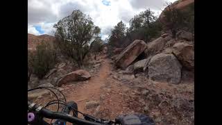
Description
The
Shamrock Trail (Y-11) can be ridden as a loop or out n' back. To ride the loop, follow CR Y-11 as it follows the San Miguel River towards the confluence with the Dolores River. Past the confluence, you'll see a large drainage coming in from the left with a rugged two-track coming down.
Follow the two track up for about a half mile until you see a rock cairn marking the Y-11 singletrack coming down from the left. This section is mostly rideable as it climbs up to a broad bench. Here the trail begins the descent back to the iron bridge. The upper section is fast and becomes quite technical as you negotiate this ever-changing and challenging trail. Caution should be used as there are more than a couple of exposed sections that the trail gets close to.
For the out n' back, take the trail which can be seen on the south edge of the large open area Follow for 3.5 miles as it gradually climbs the bench and up to where it starts descending into the Saucer Basin drainage. Enjoy some great views before your return back down the trail.
History & Background
Old cow trail used to access Saucer Basin.
Trail sits directly across the canyon from the Hanging Flume. David Lavender wrote in his 1940's book "One Man's West" about coming home for Christmas Eve to his family at the Club Ranch (Uravan) at night in a snowstorm on horseback via the Shamrock
Trail.
Contacts
Shared By:
Paul Koski

 Continue with onX Maps
 Continue with Facebook


 Difficult

 4.5 (8)


5 Comments