Dogs Unknown

Overview
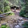
This is one of those rides that seems to have a little of everything to love about mountain biking.
-Views? You bet. The Bitterroot and Beaverhead mountains and the Salmon, Big Hole, and Bitterroot valleys.
-Singletrack? Open meadow ridges and forested descents. Enough rocks and roots to keep your attention without becoming overwhelming. Plenty of switchbacks to practice on.
-Climbs? While there is a lot more fast downhill than there is climbing, there is at least one climb to make you feel like you have earned the right to your gravity enhanced fun.
-Crowds? Forget about it.
There are so many options for riding on Warm Springs Ridge, picking the one classic route is a challenge. Taking
Shields Creek or
Colter Creek out to Overwhich Falls adds an extra sense of remoteness and more technical riding.
Fire Creek Trail #404 is an amazing descent.
Porcupine Creek Trail #205 has switchbacks galore and a visit to Two Good Cabin, along with the creekside fun of
Warm Springs Creek #103.
Still, by staying on
Warm Springs Ridge Trail #177 the whole way you get the highest proportion of singletrack, the best views and a fantastic finish.
Need to Know
This ride is usually performed as a shuttle. There are no commercial services so you'll need to set your own. Leave a car at the parking lot for Lost Trail Powder Mountain or 2.0 miles up the dirt road where the road leaves the ski area and a second on the pullout at the junction of Medicine Springs Road and Hwy 93.
The bottom two miles has the occasional rubber water bar. They are annoying and can toss you if you aren't prepared for them.
Description
Balance your aversion to climbing with your need to get back to beer after retrieving your shuttle vehicle by with dropping a vehicle at the base of Lost Trail Powder Mountain or skip most of the climbing by driving 2.0 miles up
Lost Trail - Saddle Mountain Road.
At this point the road hangs left and leaves the ski area heading for a pleasant gravel road cruise along the state divide between Montana and Idaho. The cirque to the ride holds a huge cornice during the winter.
At 3.3 miles the road forks off the right, but that is for some other day for when you decide to ride
Colter Creek or the State Divide trail back to the south. Keep on riding around the knob and towards Saddle Mountain.
The poorly marked trail leaves the road around 4.5 miles. I'll confess the trail does not start out with a bang. There is an old burn, the sidehill is a bit steep and I regularly bang my pedals on the uphill side. A little past 5 miles there is a steep downhill to the start of
Shields Creek. This is probably the steepest section of the ride and after this this trail starts to reveal its true character.
From this point and onward, the trail starts to flow as it loops behind Saddle Mountain and down to Porcupine Saddle. At the saddle the trail seems to disappear. The trail can be found in the trees on our your right or just plow ahead a bushwhack up the grassy hill in front of you to the south and you'll eventually find it towards the crest.
At the top, take a breather and enjoy the unobstructed views. The next four miles reward you with blissful riding through a high alpine meadow. Around nine miles into the ride,
Porcupine Creek Trail #205 drops off a ridge to the left. The intersection is a bit indistinct. Make sure you stay right. At 11.5 miles the trail seems to head straight down a ridge. However if you go straight, the trail dead ends at a hunter's camp, watch close for a hard right just before the descent flattens out.
Leaving the meadow, the trail drops into a sweet downhill section down to
Fire Creek Trail #404. Look closely for the trail at about 13.7 miles. It's always a tough choice whether to descend
Fire Creek Trail #404 or
Warm Springs Ridge Trail #177. Both are awesome, but for today climb a few small knobs before the final 4.5 miles down to the bottom. Be sure to check out the glimpses of Trapper Peak and the Bitterroot Valley that pop in and and of view on the way down.
Contacts
Shared By:
Lance Pysher

 Continue with onX Maps
 Continue with Facebook


 Difficult

 Divide to Twin Creek

 Good Medicine
 Elk Loop

 Coyote Coulee


3 Comments