Dogs Unknown


Be aware of hunting seasons, but otherwise the trails are open to bikes year round.
Overview
This is a good selection of trails in the RB winter area, without any of the over the top technical ones. That doesn't mean there aren't challenges to be had, just that this is a good jumping off point.
This ride can be easily broken into two separate rides, an east and a west loop. Also, the short jug handle loop of Sheller's Shanty and Meixell trails does not get as much use as the others, so be prepared for the trails to be in less than ideal condition. BEMBA is working with Forestry to improve these and other trails in the region, so hopefully that will change.
Need to Know
The trails and roads in Bald Eagle State Forest are pretty well marked, but in a very odd fashion. DCNR will mark the name of the road or trail and then underneath it note the name of the next intersecting road with a little arrow before or after it. This can lead to confusion until you understand that whatever trail or road you are on is at the top of the sign.
There is very little cell reception on this ride and it's pretty remote, so be prepared to get yourself out of the woods in case of an emergency.
Description
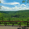
Starting out of the parking lot of McCall Dam picnic area, head north on the road and look for White Deer Creek trail on the left. Turn left and follow along on this very popular route (the general preferred direction is West to East, but it really isn't that bad East to West) as it winds up the stream valley. Some smaller rock gardens punctuate the trail, but all in all it's pretty moderate. At the end of the trail, turn right on Black Gap Rd. Very shortly take another right onto Engle Road and start climbing. There is a great view of the valley at the top of the climb.
After the view, look for a left on
Heintz Trail. Heintz is a doubletrack, fairly level with multiple mud holes even at the height of summer, so pay attention. Cruise down it just about a mile and then start looking for
Mags Path. Turn right on
Mags Path and head downhill. Be careful if the ferns are out in the Summer as they can hide big obstacle.
When
Mags Path hits Schwenk's Gap Rd, turn right and head down hill. In quick succession, Turn Left on McCall Dam rd and then Left on Breon Rd and start climbing. Look for a deer fence on the left. At the end of the fence should be Sheller Shanty Trail. Take the trail over the ridge and begin a fairly steep descent into the valley over a mile long. The trail doesn't get much use, so be on the lookout for new debris in the trail. When it levels out, take a hard right and follow along an old road bed.
When the road bed gets to an old sketchy bridge, the trail turns right and follows the creek drainage uphill (At some point the trail becomes Meixell but no sign exists on the trail). This trail climbs up gradually for a while and crosses the drainage at one point. The GPS route will veer off the red blazes at a little above this point and follows an old Blue blazed trail up the drainage. BEMBA is working with DCNR to reroute the trail to this older path, as its more sustainable and makes for a better climb (the other route is a hike a bike).
When Meixell Trail hits Breon Road again, turn left and start climbing. Look for
Green Gap Trail on the right. Currently, Green Gap is a hike a bike from Breon Rd, but there are plans to look at a re-route. Once you get to the top of Green Gap, the Descent is more than worth with it, with a pretty consistent drop down through short rock and root gardens. When it hits White Deer Creek Road, turn left and head East. In less than a half mile, turn left on Garden Hollow rd and start the short climb to
Duncan Trail.
Duncan is classified as a "driveable trail" which means its not a road and has a fair amount of rocks, but it's not quite singletrack either. At the end of
Duncan Trail, Turn right downhill and head down the short distance on Cooper Mill Rd to
Cowbell Hollow Trail. Cowbell Hollow is more than worth the effort it takes to get here. It starts out as doubletrack until it gets to a large food plot field, and then it turns into a ribbon of trail.
There is one short descent and then a long drawn out climb before the trail really drops for over a mile and half back to White Deer Creek Road. At the end, be careful as there are some short washed out sections that can throw you. At White Deer Creek Rd, take a right and start the long ride back to the beginning.
Contacts
Shared By:
Frank Maguire

 Continue with onX Maps
 Continue with Facebook


 Difficult

 Halfway Dam Epic

 Mifflin…, PA
 The Western Territories Ride
 Raccoon Mountain Beginner Loop


0 Comments