Dogs Unknown

E-Bikes
Unknown

This route crosses private property and lands managed by the BLM and the State of Idaho. Please respect all property and help maintain access by treating the area right. If gates are closed, close them behind you. If gates are open, leave them open.
Description
By my GPS, this is a 14 mile long ride w/ about 2,400' of elevation gain.
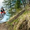
It starts at the intersection of Rock Creek and Gillman Flat roads and it includes a lot of ups and downs. The condition of the roads is highly variable. One minute you'll find yourself pedaling along easily over a good road surface, only to hit a steep climb or descent next, which might include areas of sand, large embedded or loose rock, and other challenging conditions.
Check out the elevation profile of the ride. You are looking at four distinct climbs along the course of the route; with lots of other, less significant climbs thrown in for good measure.
After you've ridden about 1.5 miles on Gillman Flat Rd., at the bottom of the first major descent, bear left at the unsigned intersection. This road will lead you up through an old mining claim and tops out at an intersection. Bear right and descend for about another 1.5 miles to a faint road intersection on the left. At this point, about 4.3 miles into the ride, look for a faint road crossing a small meadow-like area on the left.
Turn left onto the faint track and cross the meadow. Now the road begins a long climb that gets progressively more demanding. After a little while the road takes riders into a drainage where the road ascends a wetter draw. Cottonwood trees add a refreshing bit of shade and a cooler atmosphere to this portion of the outing.
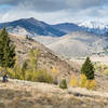
After some really steep climbing the route tops out on a barren ridge with an nice 360 degree view. The Bennett Hills and the Camas Prairie stretch out below and landmarks like Magic Reservoir and dark lava flows of the Snake River Plain provide added interest to the view. Even more spectacular are the Smokey, Boulder, and Pioneer Mountain Ranges, all within view.
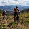
Stay on the main road to follow the main backbone of the ridge trending southeast. The road swings back to the north as it descends off of the ridge. Departing the ridge involves a short descent over a steep, rocky segment of two-track road that leads to gentler terrain.
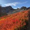
Next, the route descends through a high meadow called Sky Ranch Flat. The area has a more remote, protected feel to it, and the area is home to some stands of Willow and other cover that wildlife take advantage of.
The remainder of the route includes more descending than climbing, but there are still a number of pulls in front of you before you are back to your starting point.
All in all a pretty interesting place to ride a bike.
Contacts
Shared By:
Chris Leman

 Continue with onX Maps
 Continue with Facebook


 Difficult


1 Comment