Dogs Leashed


The park is open to hunting, be respectful of other users. Riders will encounter hunting activities in the fall and also in spring turkey season. It is discouraged to ride during hunting seasons and wet periods. Laurel Run Trail and the eastern portion of
Ridge Top Trail are closed to biking.
Overview
The Loop @ Yellow Creek State Park is over 90% singletrack and consists of nearly 21 miles of sustainable, well-groomed/well-marked trails encircling Yellow Creek Lake enjoyable by beginners and experts alike. This ride provides multiple out-and-back opportunities without having to commit to the entire loop.
There are over 25 miles of multi-use trails within the state park. The ride consists of the official park named trails consisting of
Paul Trail,
Ridge Top Trail,
Simpson Trail, Damsite Trail,
Black Hawk Trail,
Stake Church Trail and
Handlers Long Haul Trail.
Need to Know
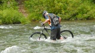
Your feet will get wet crossing the spillway below the dam unless you do an out-and-back ride. Both directions around the lake are rideable, with the clockwise direction being the preferred route. The spillway crossing can be high during the springtime.
Ride Time: 2.5-4.5 hours
Getting There:
Pittsburgh, PA: 1 hour
State College, PA : 1.25 hours
Raystown Lake, PA: 1.45 hours
Harrisburg, PA or Cleveland, OH: 2.75 hours
Baltimore, MD or Washington,D.C.: 3.25 hours
LOCATION: 11 miles east of Indiana, PA at the intersection of Route 422 & Route 259.
Trail Map:
A map of Yellow Creek State Park, including mountain bike & hiking trails can be found at the following link:
dcnr.state.pa.us/cs/groups/…
Description
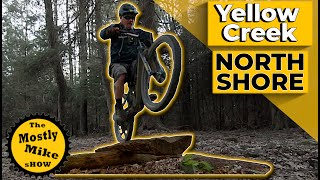
The singletrack winds through mostly forested areas and contains over 2000 of climbing. Known for its combination of flow, climbing and technical terrain, the essential definition of a classic ride, the trail system can be accessed at multiple locations throughout this Pennsylvania State Park.
The south shore Day Use Area is great for you to start your riding experience and provides plenty of parking, water, picnic areas, restrooms, and other family activities. While on the south shore, riders will enjoy fairly smooth and twisty singletrack. The north shore provides riders with more technical riding and typically the driest trails. In general, the western portion of the park will provide pleasure to those seeking climbing opportunities. Most of the trail segments can be ridden in either direction, with a clockwise direction of travel being a preferred method of travel while performing the entire loop.
Each trail segment is marked and coordinated with the park map, making navigation easy. This trail system would not have been possible without the extraordinary efforts of the Laurel Highlands On & Off Road Bicycling Association (LHORBA) (www.lhorba.org),
Friends of Yellow Creek State Park (www.friendsofyellowcreek.org), RideYC (www.rideyc.com) and the Yellow Creek State Park (www.dcnr.state.pa.us).
Ridge Top Trail, Damsite Trail and parts of
Stake Church Trail are the original park trails prior to the official start of mountain bike trail building in 2004.
Other park activities include camping within and near the park, boating, boat rentals, canoe & kayak rentals, fishing, swimming, hunting, picnicking, orienteering and hiking. Please be respectful of other users. Riding is discouraged during hunting seasons and wet periods.
Combine this ride with other local IMBA Trail Solutions (Allegripis Trail) and IMBA Epics (Rattling Creek, Coopers Gap, Rothrock Ride) and multiple riding opportunities around Pittsburgh for a weeklong Epic riding experience in PA.
History & Background
Yellow Creek State Park, established in 1963, is a Pennsylvania State Park on 2,981 acres in Indiana County, Pennsylvania. Yellow Creek Lake (720-acre) was built in 1969 by an earth and rock dam on Yellow Creek and Little Yellow Creek streams. Some of the trails are named after local families whose properties were consumed to create the state park.
Contacts
Shared By:
A.J. Kindya

 Continue with onX Maps
 Continue with Facebook


 Difficult

 4.2 (30)


5 Comments