
 Continue with onX Maps
 Continue with Facebook


 Difficult

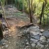
“Technical, tight singletrack with some rock ledges thrown in. ”


0.4
Miles0.7
KMSingletrack
 Difficult
Local Club: SORBA - Appalachian Mountain Bike Club (AMBC)
Dec 27, 2023: What a year it’s been – 2023 Recap!!!
Dec 18, 2023: AMBC NOTICE OF REQUEST FOR PROPOSALS
Sep 25, 2023: CONCORD BALLFIELD TRAIL PLAN UPDATE
Land Manager: Legacy Parks Foundation
 Easy Rider - Hastie
2.2 mi 3.6 km • 189' Up 57.48 m Up • 181' Down 55.32 m Down
 Knoxville, TN
 Baker Creek Demo Loop
3.9 mi 6.3 km • 280' Up 85.22 m Up • 279' Down 85.05 m Down
 Knoxville, TN
Urban Wilderness Advanced Loop CW
Knoxville, TN
Urban Wilderness Advanced Loop CW
23.0 mi 37.1 km • 2,151' Up 655.72 m Up • 2,152' Down 655.99 m Down
Knoxville, TN
 UW Extra Credit Loop
8.0 mi 12.9 km • 1,607' Up 489.68 m Up • 1,600' Down 487.73 m Down
Meades Quarry Loop
6.6 mi 10.7 km • 854' Up 260.2 m Up • 857' Down 261.18 m Down
 City Side Scenic Loop
5.9 mi 9.5 km • 805' Up 245.43 m Up • 811' Down 247.2 m Down


 All Clear


0 Comments