Dogs Off-leash

E-Bikes
Unknown
Family Friendly
Minimal climbing, few "mandatory obstacles" and options to shorten the ride make this a great loop for all ages and abilities.

Be aware of PA hunting seasons. I would not recommend being there during rifle season.
Overview
If you haven't ridden the trails at Jake's Rocks before, are new to riding or just waiting for your friends who you know will be late, this is a great short loop that will bring smiles. You should be back to the trailhead in anywhere from 20 minutes to an hour depending on your speed. This loop is fun in either direction, but riding it counterclockwise as described here will having you going downhill through one of the few rocky bits on G Trail.
Need to Know
If you need to cut it short for any reason, the road crossings make it pretty easy to bee-line for the parking lot.
Description
This ride starts from the Picnic Area parking lot at Jake's Rocks National Recreation Area. Either before or after your ride, be sure to check out the overlooks at the far end of the spur road for views of big boulders, sheer cliffs and great vistas. Start the ride by taking a right at the first Y intersection and cross the scenic drive loop.
The F Trail starts off with a few tight, twisty bits and a little climbing before crossing the loop road a second time. If the leaves are down, be sure to keep an eye to the right, as you should be getting some good views across the reservoir as you are about 1,000 feet above the valley floor. The trail rolls through some cool fern meadows and over some rock features, including several built optional lines. Most of the lines are easy to roll, but be prepared to wheelie drop just in case.
At about a mile and half, the trail will turn away from the reservoir and climb slightly until you cross Forest Road 160. From there, it will descend gently until you reach the intersection with H Trail and F Trail. Stay to the left to begin climbing up the G Trail to
Coal Knob.
Coal Knob used to have a fire tower on it, so you'll know you are getting close to the top when you pass a rundown shack that used to be the outhouse. The knob itself is one massive sandstone boulder that you'll carve across, creating a little eastern slick rock. If you look closely, you'll see the US Geological survey badge in the rock, as well as the name of the person who manned the fire tower for some period of time (long enough for him to carve his full name in 4" high letters).
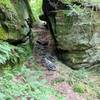
After you roll through the slick rock, you'll descend the few rock gardens on the loop. They aren't too challenging, but they look extra cool as they slot through the boulders, so there is no shame in having to walk a little bit to admire them. After the rock chutes, the trail enters a fun and flowing downhill section back to the loop road. From there, it's a pretty flat traverse back to E Trail. Stay left here to return to the start.
History & Background
As mentioned,
Coal Knob on G Trail is one of the high points in the area and contains some cool historical markers. It's worth stopping and checking out the bits of the forest's past.
Contacts
Shared By:
Frank Maguire

 Continue with onX Maps
 Continue with Facebook


 Easy/Intermediate

 Big Loop

 Warren, PA
 Rocky Gap ATV trail
 Tanbark Trail


0 Comments