Dogs Unknown

E-Bikes
Unknown
Description
This trail starts at the University Falls Trailhead. It begins with a steep and technical climb, crosses OHV trails a few times, and then descends steeply to University Falls.
Be sure to always take a moment to hike down to the falls. It's a very short hike and there's a hitching post to hang your bike from. University Falls is a very nice waterfall and a nice touch of scenery to this dense forest ride.
Afterwards the trail begins a lengthy, technical descent to the lowest elevations of the whole
Browns Camp Loop. There are a few very mellow climbs sprinkled in, but it's mostly downhill. Expect lots of root clusters and some rock gardens.
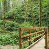
The trail crosses several streams and follows some bench-cut trail. Recent logging has opened up a section of forest that the trail runs through, so be mindful in the hottest days of summer. Don't worry though, it is brief. Eventually the trail crosses a wide stream with a nice bridge. Take a moment to stop and try to spot some trout in the clear water.
Shortly after the creek, the trail junctions with the
Storey Burn Trail, which heads west under Highway 6. Keep uphill and to the right for the gradual climb up to a decommissioned gravel road. The gravel road crosses the
Elliott Creek OHV Trail just before an ODOT gravel station, which the trail circles around behind concrete barriers. This marks the end of the
Browns Camp Loop.
After riding behind the concrete barriers, you'll arrive at the junction of Beaver Dam Road Highway 6. Climbing up the fire road and taking a left will take you to the Rogers Camp Trailhead. Crossing the highway leads to a very large pull-over parking lot and the Summit Trailhead. The Gales Creek Summit Trail will take you back to the Gales Creek Trailhead.
Contacts
Shared By:
Brock Warner

 Continue with onX Maps
 Continue with Facebook


 Intermediate/Difficult


0 Comments