
 Continue with onX Maps
 Continue with Facebook


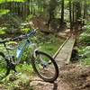
“This trail climbs close to 1,000 feet to the top of Leading Ridge. ”


1.5
Miles2.4
KMSingletrack

Land Manager: USFS - Monongahela National Forest Office
 Allegheny Mountain Loop
6.9 mi 11.2 km • 1,277' Up 389.38 m Up • 1,276' Down 388.95 m Down

 Huckleberry - Lumberjack Loop
13.5 mi 21.7 km • 1,101' Up 335.5 m Up • 1,102' Down 335.83 m Down
Whitmeadow - Stonecoal Loop
13.8 mi 22.2 km • 1,403' Up 427.72 m Up • 1,381' Down 420.9 m Down
Elkins, WV
 Nirvana
14.9 mi 24.0 km • 901' Up 274.51 m Up • 906' Down 276.05 m Down
 Cheat Mountain Loop
14.5 mi 23.3 km • 1,085' Up 330.72 m Up • 1,101' Down 335.5 m Down
Silver Creek Route
8.0 mi 12.9 km • 1,002' Up 305.41 m Up • 1,033' Down 314.75 m Down


0 Comments