Dogs No Dogs

E-Bikes
Unknown

The
Ohakune Mountain Road is an alpine road that is often closed in the winter due to snow, ice and strong winds. Even in summer, temperatures can be low, and winds can be strong. Always check conditions first and dress accordingly. TCB can advise on all local track conditions.
Overview
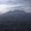
This stunning route starts at an altitude of 1,620 meters at Turoa Ski Field car park, on the western slopes of Mt Ruapehu, an active volcano! On a clear day, you can see as far as the South Island. The lower slopes of Mt Ruapehu are covered in beautiful native forests, the upper slopes give unparalleled views. The entire ride is downhill on a public sealed road through the Tongariro National Park.
Need to Know
Leave your car at TCB and catch the shuttle to the top of the road; then it's downhill all the way back to your car, about 19 kms. Shuttles leave TCB every day at 11am and 1pm, and only cost $15.
The top half of this road is fairly steep and is all downhill, so make sure your brakes are in very good condition. Mountain bikes with v-brakes are NOT recommended.
Description
This stunning route starts at an altitude of 1,620 meters at Turoa Ski Field car park, on the western slopes of Mt Ruapehu, an active volcano! It is worth spending some time at the Turoa base area to take in the amazing views to be had from this altitude. On a clear day, you can see as far as the South Island. The entire mountain road is now sealed.
As you start your descent down Mt Ruapehu, the stunning views continue for several kilometers until you enter into the forest. Just below the hairpin turn there is a spot that was used in "The Lord Of The Rings" where Gollum chases a trout up the river. There is a small car park and also a very short walk to a waterfall.
Further down the mountain is an excellent walking track to the Waitonga Falls. It is a beautiful 1.5 hr return walk to the tallest waterfall in the Tongariro National Park. This track is walking only, so take a bike lock with you.
The mountain road starts to flatten out after this and winds through magnificent native forest until you reach Ohakune.
Unless you are keen enough to ride up the mountain first, you'll either need someone to drop you off at the top, or catch local transport from Ohakune. Dempsey Buses have regular shuttles that run from TCB every day at 11am and 1pm for $15.
TCB are the only bike shop in the district, and they can advise you on all local track conditions. They also sell, hire, and fix bikes, 7 days a week.
History & Background
As early as 1913, the Ruapehu Ski Club began to request accommodation on Mt Ruapehu and the first hut was constructed in 1922. However, it was not until 1934 that the community began to seriously consider the possibility of a commercial ski field on Ruapehu. This would of course require better access than the existing horse trail.
After several failed petitions to the Government, the residents took matters into their own hands and, in 1952, the Mountain Road Association was formed. Initial work began immediately but with limited resources and funds. The majority of the work was being undertaken by local volunteers and it was extremely slow going. After almost 10 years of construction work, additional funding was finally secured from the government but it still took five more years to complete.
Eventually, in 1976, the road was declared legal and in 1978, Turoa Skifields Ltd began its commercial operations on the mountain.
Contacts
Shared By:
Peter Blakeman

 Continue with onX Maps
 Continue with Facebook


 Intermediate

 4.8 (4)


0 Comments