
 Continue with onX Maps
 Continue with Facebook


 Intermediate/Difficult

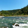
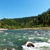
“This trail is an alternate connector to the Confluence Trail from Old Foresthill Road. ”


1.4
Miles2.2
KMSingletrack
 Intermediate/Difficult
Land Manager: Auburn State Recreation Area (ASRA)
 ASRA 7 Mile Loop
7.4 mi 11.9 km • 1,095' Up 333.79 m Up • 1,095' Down 333.82 m Down

 North A…, CA
 Confluence to Maine Bar
10.3 mi 16.6 km • 1,159' Up 353.3 m Up • 1,160' Down 353.71 m Down
Foresthill Connector to Confluence
7.4 mi 11.9 km • 536' Up 163.47 m Up • 1,656' Down 504.62 m Down
Auburn…, CA
 Salmon Falls Trail to Flagstaff Hill
14.1 mi 22.7 km • 1,929' Up 588.01 m Up • 1,927' Down 587.49 m Down
Old Miners' Loop from Town
10.4 mi 16.8 km • 1,266' Up 385.85 m Up • 1,272' Down 387.6 m Down
Fleming Meadow Loop
6.5 mi 10.5 km • 949' Up 289.39 m Up • 979' Down 298.41 m Down
Pollock…, CA


 Minor Issues


0 Comments