
 Continue with onX Maps
 Continue with Facebook


 Difficult

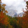
“The Colorado Trail Segment 22 is a 17.2-mile trail that runs along the Continental Divide and tops out at 13,271 feet. ”


17.6
Miles28.3
KMSingletrack
 Difficult
Land Manager: USFS - Gunnison National Forest
 Bristol Head
15.4 mi 24.7 km • 1,753' Up 534.39 m Up • 1,753' Down 534.39 m Down

 FSR 523/524
14.1 mi 22.7 km • 2,085' Up 635.4 m Up • 2,080' Down 633.89 m Down
 Wasatch Trail Loop
15.8 mi 25.4 km • 4,305' Up 1312.12 m Up • 4,310' Down 1313.65 m Down
 Telluride, CO
See Forever/Wasatch Connection Loop
Telluride, CO
See Forever/Wasatch Connection Loop
8.5 mi 13.7 km • 1,621' Up 494.05 m Up • 3,405' Down 1037.81 m Down
Mountai…, CO
The Gentleman's Loop
15.3 mi 24.7 km • 728' Up 221.78 m Up • 2,527' Down 770.24 m Down
Mountai…, CO
 Tour de Engineer
19.5 mi 31.4 km • 2,380' Up 725.51 m Up • 4,335' Down 1321.17 m Down
Silverton, CO


2 Comments