
 Continue with onX Maps
 Continue with Facebook


 Intermediate/Difficult


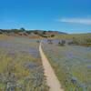
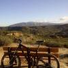
“An old ranch road that is steep in places. Watch for steep loose bits. ”


2.4
Miles3.9
KMDoubletrack
 Intermediate/Difficult
Local Club: Monterey Off Road Cycling Association
Land Manager: Monterey County - Parks
 Pipeline Loop
9.3 mi 14.9 km • 1,616' Up 492.63 m Up • 1,616' Down 492.47 m Down
 Salinas, CA
 Best of Ord - Short
17.9 mi 28.8 km • 2,176' Up 663.12 m Up • 2,177' Down 663.56 m Down
Salinas, CA
 Inter-Garrison Rd to Kyle's Bench loop.
8.7 mi 14.0 km • 468' Up 142.59 m Up • 486' Down 148.13 m Down
Road Runner to Razorback
5.2 mi 8.4 km • 702' Up 213.88 m Up • 702' Down 214.09 m Down
 Wilder Ranch Coast Trail
14.3 mi 23.1 km • 144' Up 43.94 m Up • 144' Down 43.9 m Down
Santa Cruz, CA
 Best of Wilder Ranch
16.6 mi 26.7 km • 1,371' Up 417.87 m Up • 1,361' Down 414.73 m Down


0 Comments