Dogs Leashed

E-Bikes
Unknown

Riders must be aware of deer hunting season dates in the fall. Off-trail riding is not allowed in the Sunbridge Hills.
Description
The trail is best ridden counterclockwise but is rideable in both directions. The upper portion has many water bars, but they aren't too hard to negotiate.
Heading counterclockwise from the parking lot, you'll pass an old cemetery and a steel observation deck. After the steepest water bar section, you'll turn off the main trail, heading south. There are two ways down. The first left is the easier benched way down. The second left is a very steep downhill with a tight left turn that has a bit of exposure. You decide which is best for you. The views past the turn-offs are worth your time to check out before heading down the hill. Continuing straight is
Lowrider.
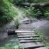
The "lower" section of the trail has some rock, but it's not necessarily technical. There is a substantial drop-off beside the trail in places. A few places are narrow and the exposure is quite high so it is NOT a place to bring little kids out for a ride.
When this lower section of the trail reaches the power lines you'll enter River Bluff Trails Park. You'll take
Devil's Corner down the hillside to
Jekyll & Hyde. The most direct route back to the conservation area and it's parking lot is via Low Rider &
Sunbridge Road from
Jekyll & Hyde. Just before reaching the road, turn left on
Comeback and this will lead you back to the conservation area where you can turn left on
South Shortcut from the Upper Field or straight for a longer and more hilly route that is shown as the beginning of this GPS track.
Most of the trail provides incredible views of the river valley. Trying to mark them all on the map would fill the map with "view" symbols. Due to areas of exposure, be sure to look at the trail when moving!
Contacts
Shared By:
Lee Clark

 Continue with onX Maps
 Continue with Facebook


 Intermediate


1 Comment