This ride from Packer Saddle starts on the new
Gold Valley Rim Trail, for some truly excellent singletrack. The
Big Boulder trail is arguably the best descent toward Downieville off Packer Saddle shuttle drop off, but you'll have to do a little climbing to earn your descent. Less skilled riders will have a tough time with the down trail, but those with advanced skills who love fast, flowing, long, continuous descents will be itching for another lap.
The navigation is a little tricky as there is no signage for
Big Boulder until you cross Pauley Creek, so until then follow the directions for Pauley creek. Then you have to be mindful of the unmarked fork about half way through the climb where you take a left, I believe the marker says OHV trail or something similar for the trail to the left whereas it says nothing for the section going straight. When in doubt, use the
MTB Project mobile app!
Pick up the trail at Packer Lake Saddle (intersection of County Route 621 and Butcher Ranch Rd.), just a short distance from the shuttle drop off at the top of
Sunrise Trail. (It will be down the hill from the shuttle drop off. The shuttle drives past it on its way to
Sunrise Trail.)
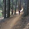
Gold Valley Rim Trail starts with a gradual climb to obtain the ridge where you are rewarded with sweeping views of the Lakes Basin. After riding along the ridge, the trail crosses a couple small service roads where it then deviates from the old PCT and begins to drop down toward "Baby Heads" on new singletrack. The descent is on par with the many great descents in the Downieville trail system with plenty of rocky technical sections. The trail crosses over several sections of rock slab that gives you a little taste of Moab riding, Sierra style. Look out for a great optional slab descent feature about 4.7 miles in.
The trail ends at an intersection with Forest Service Road 93-3. Follow signs straight to continue on to "Baby Heads" and the start of Pauley Creek /
Big Boulder trails.
Once you cross Pauley Creek (it's a large meadow), you'll climb out of the creek and then watch for the
Big Boulder turn off on your right. Keep climbing until you come to another fork. The trail you want to take is the option on the left; there is a sign proclaiming it an OHV trail; that's the only confirmation you'll have once heading towards
Big Boulder.
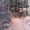
You'll begin a well-earned descent here, and one that is as much fun as you can find anywhere in the Downieville area. The trail is fast, flowy, a little technical, and a little dangerous. You'll head through exposed sections and through the woods, FAST.
Big Boulder ends at
Third Divide for some more fast downhill flow. It's all ripping fun until you get to Lavezolla Road and head toward First Divide.
From Lavezolla Road, you'll come to an obvious open area just before the fire road starts upward, where
First Divide (upper portion) sneaks off to the right. Look for a little sign that says "Trail" with an arrow. First Divide is relatively flat/descending singletrack, pedaling most of the way. At times it's quite narrow with a rock face wall on one side and a drop off small cliff on the other.
At the end, you can cross the fire road and continue onto
First Divide (lower portion), which will be a singletrack on your right. The
First Divide (lower portion) is rocky singletrack mostly along a rock edge, with a small bit of climbing. It's a short stretch, but technical in spots, so be particularly attentive. The difference here is that if you go off trail, it's a long way down.
This last portion puts you onto a paved road, which you'll follow mostly downhill about a mile back to Downieville.

 Continue with onX Maps
 Continue with Facebook


 Difficult

 4.6 (19)


7 Comments