Dogs Leashed

E-Bikes
Unknown

Closed to bikes December 15th - April 15th.
Overview
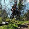
This route uses a combination of beautiful single lane gravel roads, singletrack, and just a little bit of pavement to link up a great ride. The downhill sections are what make this ride great. They are fast and steep descents followed by climbs that will make you sweat!
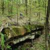
At one point, you skirt the edge of a waterfall just before traversing right along the edge of the Little Muskingum River. You'll pass a couple of old stone foundations from 200+-year-old structures that are now long gone. The only drawback of this ride is one mandatory hike-a-bike section when climbing back up from along the river. The other drawback is mid-summer vegetation growth along the river bottom. Check trail conditions to see if things have been cleared before heading out especially June, July, and August.
Need to Know
The trail in this area is classic, old school trail with steep climbs and descents. The layout of this route uses lower gradient roads to handle most of the climbing. Use caution when descending as many of the trail segments are extremely steep and have some exposure in a couple of areas. There aren't any amenities at the trailhead and cell phone service is spotty so plan on bringing everything that you'll need. Marietta Brewing Company on Front Street in Historic Downtown Marietta is a good stop if you're ready to refuel after your ride!
Description
The ride begins with a few miles of climbing the ridge line on a single lane gravel road. It's a nice rolling climb high on the ridge. At the highest point on the ridge, you'll hang a right onto the
Pioneer Trail/North Country Trail: Bear Run Descent singletrack. After a short stretch, you cross a gravel road and shoot up a steep little bank on the other side. From this point, the trail begins a super fun downhill known to locals as the "Bear Run Downhill" as it drops you out onto Bear Run Rd (CR 25).
Turn right on CR 25, and you'll begin a paved climb up to the top of the next ridge. At the top of the ridge, you'll turn left onto CR 9 and follow it for a couple of miles before turning left onto Felter Rd. This gravel road circles around and intersects the trail. The trail crosses Felter Rd at the bottom of the second small hill on the road. Watch for the trail signs, they're easy to miss. At this point, you'll turn left onto the
Pioneer Trail/North Country Trail: Pipeline singletrack. This is approximately the halfway point of the ride.
The rest of the ride is all singletrack from here. The trail crosses a few roads, but there aren't any other trails that intersect it. The next section is a downhill/valley trail known to locals a "Pipeline." It won't take long to notice the numerous gas lines criss-crossing the trail running down the valley. The lines can be slick so keep your eyes open! The top of the downhill is high speed leading into a tight switchback.
After a short traverse along the hillside, the trail drops to the bottom of the valley. From here, the trail crosses a winding stream multiple times before bringing you back to the bottom of the "Bear Run Downhill" which you now will climb back up. This is a great, challenging climb that is 100% rideable if you've got your game face on! At the top of the hill, you can continue on the singletrack or hang a right on the gravel road up to the next trail crossing if you're looking for a little break.
Now that you're back to the high point on the ridge, you'll be doing more descending starting with a fast drop-in that leads into some fast pedaling sections along
Pioneer Trail/North Country Trail: Bean Ridge. After one very short climb that crosses a dirt oil well road, the trail starts to speed up until you reach the main descent to the Little Muskingum River. This is a big, fast, steep descent. Watch your speed because some of the switchbacks can sneak up on you. Once you make it down to the river, the trail is flat and twisting along the water's edge for more than a mile. Use this section to recover before the final climb. The final climb begins with a mandatory hike-a-bike section for a couple hundred yards. Beyond this you can ride everything else to the top of the hill. From here you've got it made. One twisting, fast, fun downhill is all that lies between you and your car. Enjoy!
History & Background
This area has a long history in the oil and gas industry and was home to a huge oil boom in the 1880's. Cow Run was home to one of the largest oil discoveries in the state. Southeast Ohio lays claim to the first oil discovered from a drilled well in 1814, and nowhere else in North America has commercial oil and gas production existed longer than that located within the Appalachian Basin. Relics from oil and gas exploration in the 1800's can still be seen around the forest.
Contacts
Shared By:
Ryan Smith

 Continue with onX Maps
 Continue with Facebook


 Very Difficult

 North Marietta Tour

 Marietta, OH
 Wayne Mini-Epic
 Pioneer Trail: Lamping Homestead to Marietta
 Johnson T. Janes Park Loop


0 Comments