Dogs Off-leash

E-Bikes
Not Allowed

Avoid riding in damp conditions. Dogs require a permit from the Dept of Conservation, St Arnaud.
Overview
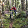
The singletrack is a natural surface through sub-alpine native bush with many technical challenges including two sets of climbing switchbacks. There are two or three sections some people may have walk, including a steep section dropping through a number of switchbacks. This section is chock full of roots and small drop-offs to a saddle. An overlook provides extensive views down the Wairau Valley.
Need to Know
There is no water along the route until Red Hills Hut and in dry conditions this cannot be relied on. There is a good creek where the 4wd road enters the bush, about 1500m below the hut. This is an alpine route in remote country where cold temperatures can be experienced at any time of the year. Be prepared with warm clothing and wet weather gear. Be sure to grab some great coffee and pizza at the Alpine Lodge, St. Arnaud after the ride.
Description
Park at the Upper Six Mile Creek Carpark off Highway 63 and ride west up the hill, turn right on Tophouse Rd for 800m then right up the signposted 4wd track to Beebys Knob. It starts with a challenging 600-metre climb on the 4wd road to the start of 6 miles of singletrack at 1300m elevation. The trail (
Maitland Ridge) is signposted and marked with a cairn and a large orange triangle on the right where the 4wd track emerges from the bush into open tussock country. MTB Trails Trust has built
Wots up Doc, a climbing track that takes out the steepest parts of the 4wd track that leads to the start of the track.
The
Maitland Ridge singletrack starts with a 2.5km descent to 1030m through sub-alpine beech forest to a saddle, then climbs in a series of switchbacks to a gently climbing ridge. The track passes through several tussock clearings offering views out to the surrounding country before climbing another set of switchbacks to 1202m through "Lord of the Rings" type forest.
From here, the track descends ever steeper, culminating in a technical section of steep, rooty switchbacks before reaching another saddle at 1000m. An easy graded climb through bush and low scrub is followed by a fun, rocky 120m descent through stunted mineral belt scrub to Red Hills Hut.
The
Maitland Ridge singletrack ends at the Red Hills Hut where a rocky 4wd road takes riders down to the valley floor. Simply follow the orange trail markers, which will lead to another 1500 metres of rooty, challenging singletrack back to the starting point at the carpark. A new track 200m after the end of the 4wd road leads off to the right and bypasses the steep challenging section of the carpark track.
History & Background
Parts of the track follow an old survey line that forms the boundary between Nelson and Marlborough. Several old wooden survey pegs placed in 1916 were found in good condition when the track was being built. They were put in by the then District Surveyor, H Maitland.
Contacts
Shared By:
Alan Eskrick
with improvements
by Chris Longliveenduro

 Continue with onX Maps
 Continue with Facebook


 Difficult


10 Comments