The trailhead is located on the paved Urban Trail System. There is no visible sign or marker for this trail, but it's directly behind the lone green bench on this section of the paved trail. You can't miss it.
It's a VERY beginner lever trail. It used to be quite kid friendly and most of it still is. In 2012, the city annexed the paved trail system. In the process, they literally cut off the northern section of the trail. Changes had to be made. Unfortunately, there are a few SHORT spots that are steep now. Most kids will now have to dismount on them. In spite of that, this is still my kid's favorite. Mostly because of a long tunnel that goes under the paved trail.
This is the smoothest trail in town. It's all hardpack with no rocks and only a few roots. Obviously, this makes it a very fast ride! There are long straights with many rail-able turns. There is one field that the trail intersects a few times, but navigation is never an issue.
The trail comes out of the trees a couple times at the paved trail quickly turning back into them without leaving the dirt. After going through the tunnel and making the short, steep climb beyond, the trail intersects the paved trail again. One can turn left and stay on the dirt or briefly ride the paved trail for a couple hundred feet until the trail turns left back into the trees. Sometimes, at this point, many people will skip the last bit of this trail and continue on the paved trail north to
Girl Scout Trail and
Brownie Trail and finish it on the return. The last portion does end at another part of the paved trail where this option is still possible. The VERY end is often muddy. Another reason some people choose not to do the last bit. One can turn right, where the trail rejoins the paved trail, to go to the northern parking lot. Or one can turn left at the paved path and then right at the four-way paved intersection to return to parking by the pond. The lot is visible from the end, on the paved path, because the city keeps it "parked out."
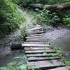
There are some log piles to roll over with bypasses. There is also a log skinny to test your handling skill, again, with a bypass if you'd rather not.
The proximity to
Corby South makes
The Corby Combo a nice 5-mile ride of low difficulty. Due to the long, smooth straightaways, it potentially has some of the speed of
Krug Park without the leg and lung punishing climbs. Alternatively, bring your kid. Go slow. And share that love of dirt!

 Continue with onX Maps
 Continue with Facebook


 Easy/Intermediate

 4.4 (5)


2 Comments