Dogs Unknown

E-Bikes
Unknown
Features
Drops/Jumps · Views
Description
Overview:
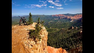
Blowhard Trail is best experienced via shuttle. It's a 7-mile downhill trail with a 3300-foot descent. Expect rowdy loose sections, raw roots, rock gardens, and switchbacks that your long-travel bike will barely fit through. A beautiful flow trail exists between the challenging sections, offering jaw-dropping views of Cedar Breaks near the top. This is an advanced trail and should be ridden with caution as sections of the trail are loose, raw, and a little unpredictable.
Getting There:
The bottom trailhead is located on the left side of Cedar Canyon, 8.6 miles up the canyon. Leave a vehicle here for a shuttle and drive up Cedar Canyon, taking a left on State Route 148. Drive 2.1 miles before taking a left on a dirt road, following it for under a mile to the small roundabout and Upper Blowhard Trailhead.
The Trail:
Start with a short climb on the obvious trail leaving the parking lot. Pedal a few hundred meters before reaching the top of Blowhard Trail. Once reaching the top of the trail, be prepared for some steep butt-scrubbing riding. Right off the bat, follow a series of short steep switchbacks leading 1.1 miles into a beautiful viewpoint of Cedar Breaks National Monument.
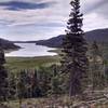
Continue down the obvious trail through the hardest part of Blowhard with more switchbacks and off-camber rock sections for the next 2 miles. The trail slowly changes from rowdy downhill to alpine flow with fun fast sections and less steep riding. Once reaching Crystal Springs, a large meadow, expect the riding to ease up for a bit.
Cross the meadow and follow the well-marked trail up a short climb before reaching the second section of downhill. This 2.8-mile trail is full of flowing downhill trail through pine trees and offers a much smoother ride compared to the trail above. From here, follow the trail into a doubletrack steep road, following a fence line downhill. After the steep doubletrack, an obvious singletrack gate stands out on your left.
Follow this trail down the remainder of Blowhard. The trail is higher speed here but has a few hard rock slabs to ride over before ending at a janky rock garden that leaves you in the parking lot.
Contacts
Shared By:
Markk Knowles
with improvements
by Marley Nelson

 Continue with onX Maps
 Continue with Facebook


 Difficult


")


2 Comments