
 Continue with onX Maps
 Continue with Facebook


 Intermediate/Difficult

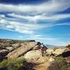
“This is a six-mile downhill romp from the base of the Pine Valley Mountains down to Washington. ”


6.8
Miles10.9
KMSingletrack
 Intermediate/Difficult
Local Club: Trail Alliance of Southern Utah (TASU)
Land Manager: BLM Utah - St. George Field Office
 Broken Mesa Loop
15.5 mi 24.9 km • 2,078' Up 633.38 m Up • 2,083' Down 634.87 m Down

 Pioneer Park Loop
1.0 mi 1.6 km • 48' Up 14.71 m Up • 48' Down 14.67 m Down

 Barrel Roll Lollipop
7.9 mi 12.7 km • 798' Up 243.21 m Up • 799' Down 243.4 m Down
Zen Trail
5.7 mi 9.1 km • 973' Up 296.72 m Up • 974' Down 296.77 m Down
Saint G…, UT
 Bearclaw, Stucki, Snakepit
18.0 mi 29.0 km • 1,177' Up 358.89 m Up • 1,187' Down 361.89 m Down
Barrel-Zen Link Up
10.8 mi 17.5 km • 1,615' Up 492.36 m Up • 1,618' Down 493.12 m Down
Saint G…, UT
")


 All Clear


1 Comment