MTB Project Logo

A nice mix of wooded and open rolling trail. Technical stunts on a few areas with optional bypasses.


Your Rating: Rating Rating Rating Rating Rating      Clear Rating
Your Difficulty:
Your Favorites: Add To-Do · Your List
Zoom in to see details
Map Key

8.9

Miles

14.3

KM

70%

Singletrack

890' 271 m

High

850' 259 m

Low

212' 65 m

Up

214' 65 m

Down

1%

Avg Grade (1°)

8%

Max Grade (4°)

Dogs Leashed

E-Bikes Unknown

Dogs must be on a 6' or less leash at all times and are only allowed in park area to the north and at McNamara Canoe Landing to the south up to the cutoff point. Signs are posted at this point, and dogs are allowed in the pond at this area only.

Seasonally trails are closed during XC ski season.

Check the MMMBA Facebook page for open/closed status. facebook.com/mmmba.org/
Trail conditions here: facebook.com/groups/midmich…

Overview

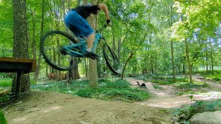
The Mountain Bike (MTB) Trail is a great mountain bike specific loop offering nearly 10 miles of excellent riding. The trail has features suitable to those with advanced skills, but multiple bail-out points make this a good place for intermediate riders to challenge their skills.

Description

The main park entrance is on Grovenburg Road, and full facilities are available at that entrance. This trail is a bit harder to find from there. Riverbend Natural Area (trailhead) entrance is off Nichols Road and there is a kiosk and clear trail markings at this entrance. There is also an outhouse there, but not potable water. The McNamara entrance off of Columbia Road features the same primitive amenities.

The MTB Trail is a series of named segments linked together, and trail maps are located at each of the three lots. Follow the orange sign posts with bike icon and directional arrows. All turns are marked with the orange signposts. mmmba.org/trails/ has links to pdfs and GPS versions of the trail.

In general, this is a nice fun trail system aimed at making use out of limited terrain within the overall area. A few optional elevated stunts will be found within the loop, with the majority of them not too far from the Riverbend parking lot. There are bypass options for all of these.

During summer months the MMMBA chapter hosts weekly group rides. The ones at Burchfield can be a great way to learn the trail plus meet other riders.

Two other trails are nearby, Bennett Park in Charlotte and Anderson Park on Old Lansing Road (currently named Blue Loop Green Loop and Red Loop and can be located that way here on MTB Project).

Contacts

Shared By:

Anne Grofvert

Trail Ratings

  4.3 from 23 votes

#785

Overall
  4.3 from 23 votes
5 Star
52%
4 Star
35%
3 Star
9%
2 Star
4%
1 Star
0%
Recommended Route Rankings

#29

in Michigan

#785

Overall
9 Views Last Month
8,406 Since Feb 13, 2015
Intermediate Intermediate

13%
8%
58%
4%
17%
0%

Photos

Fall wildlife
Apr 13, 2015 near Dimondale, MI
Riding the skills area at the Dirt School.
Jul 31, 2022 near Dimondale, MI
The builder riding Whiplash, a stunt on Hansen's Be-Bop. This is a good practice line for stunts further along in your ride. 2"x10" entry, drop to long 2"x6", drop to long 2"x4", then onto short on-end 2"x4". Yes, 2" wide at the end! This is a beginner/intermediate stunt with little risk involved
Aug 1, 2015 near Dimondale, MI
The exit of The Mambo King, a stunt on Hansen's Be-Bop. Note the advanced bit a foot on the other side of the top log in the logpile exit. It is easier to ride than it looks, but this is definitely an advanced stunt (for this part of the country).
Aug 1, 2015 near Dimondale, MI
Riding the horseshoe-shaped stunt (backwards) on Hansen's Be-Bop, which was not given an individual name. The names of the trails at Burchfield are based on movie names, though I'm not sure which movie this trail name refers to. The other stunts on this trail are named for music-related movies.
Aug 1, 2015 near Dimondale, MI
Composite picture of the builder chainsawing the Pitchfork entrance on the left, and the nearly-completed Hellboy stunts on the right.
Feb 22, 2015 near Dimondale, MI

0 Comments

Weather


Current Trail Conditions

Unknown
Add Your Check-In

Check-Ins

May 17, 2022
Brayden Guggisberg
Jul 18, 2021
Rachael Parke
Jun 11, 2021
Madeline Marigold
Lovely trail complex, well marked with lots of optional routes and bypasses, fun technical areas scattered throughout gorgeous varied terrain
Dec 16, 2020
Joe Hamm
Oct 3, 2020
Kevin Cannon
Sep 27, 2020
Rachael Parke
Sep 5, 2020
Christopher Cordle
Absolutely loved the trail. Unfortunately got a pinch flat 6 miles in and had to hike out. 6mi
Aug 17, 2020
John Overman
8.9mi — 1h 08m

Stewarded By

Welcome

Join the Community

Create your FREE account today!
Already have an account? Login to close this notice.

Get Started