
 Continue with onX Maps
 Continue with Facebook


 Intermediate/Difficult

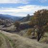
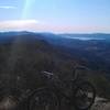
“A very challenging climb making for a very committed ride. ”


7.7
Miles12.4
KMDoubletrack
 Intermediate/Difficult
Land Manager: BLM California - Ukiah Field Office - Bear Creek Unit
 Fiske to Foley Creek to Long Canyon
27.3 mi 43.9 km • 4,262' Up 1298.97 m Up • 4,266' Down 1300.4 m Down
 Fiske Peak Loop
16.7 mi 26.8 km • 3,349' Up 1020.73 m Up • 3,356' Down 1022.96 m Down
 High Bridge to Cache Creek Ridge
12.8 mi 20.5 km • 1,724' Up 525.45 m Up • 1,719' Down 523.91 m Down
Pierce Canyon Climb
12.4 mi 20.0 km • 1,533' Up 467.2 m Up • 1,533' Down 467.22 m Down
 Moore Creek Park Loop
8.8 mi 14.2 km • 1,296' Up 394.93 m Up • 1,298' Down 395.78 m Down
Saint H…, CA
 Shiloh Ranch Loop
4.0 mi 6.5 km • 569' Up 173.37 m Up • 546' Down 166.37 m Down


0 Comments