
 Continue with onX Maps
 Continue with Facebook


 Intermediate

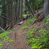
“A local backcountry trail. ”


4.3
Miles6.9
KMSingletrack
 Intermediate
Land Manager: USFS - Idaho Panhandle National Forests Office
 Hells Canyon Loop
12.0 mi 19.4 km • 1,821' Up 555.13 m Up • 1,829' Down 557.5 m Down
 Bernard Peak Loop
18.3 mi 29.5 km • 2,711' Up 826.21 m Up • 2,699' Down 822.73 m Down
4th of July Pass - Killarney Mountain Ride
12.8 mi 20.7 km • 1,680' Up 512 m Up • 1,681' Down 512.25 m Down

 Beauty Bay Loop
19.8 mi 31.8 km • 3,498' Up 1066.1 m Up • 3,490' Down 1063.76 m Down
Upper Caribou Loop
12.4 mi 20.0 km • 2,418' Up 737.14 m Up • 2,415' Down 735.98 m Down
Coeur d…, ID
 Independence Creek Tour
21.2 mi 34.1 km • 3,032' Up 924.05 m Up • 3,007' Down 916.49 m Down
Pinehurst, ID


0 Comments