
 Continue with onX Maps
 Continue with Facebook


 Intermediate


 Intermediate
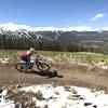
Land Manager: Town of Breckenridge, CO - Open Space Dept.
 Classic Breckenridge Route
12.1 mi 19.5 km • 1,141' Up 347.64 m Up • 1,014' Down 309.21 m Down
 Carter Park to Side Door
11.4 mi 18.3 km • 1,960' Up 597.53 m Up • 1,960' Down 597.55 m Down
Brecken…, CO
 Breck 100: Loop 2
34.8 mi 56.0 km • 4,580' Up 1396.1 m Up • 4,583' Down 1397.05 m Down
Avalanche Sports Short Ride
5.9 mi 9.5 km • 966' Up 294.47 m Up • 969' Down 295.4 m Down
Breckenridge Ski Resort
13.4 mi 21.6 km • 1,759' Up 536.17 m Up • 1,772' Down 540.13 m Down
Little French Loop
12.6 mi 20.3 km • 1,659' Up 505.65 m Up • 1,659' Down 505.53 m Down


2 Comments