Dogs Unknown

Description
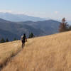
The Divide Trail is a National Recreation Trail that runs over 30 miles along the Idaho/Montana Stateline. It is also known as the Stateline Trail to differentiate it from the better known Continental Divide Trail.
The Stateline Trail runs from the backside of Lost Trail Ski Area south to the head of Spring Creek near Dutchler Mountain.
The north Section is accessed via the Saddle Mountain Road and the trailhead is just a short distance beyond the
Colter Creek Trailhead.
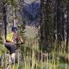
The length of the north section of Stateline Trail is excellent singletrack with a smattering of difficult climbs and descents.
The large forest fires of 2000 are evident along the trail by the charred skeletons of trees and frequent deadfall. Bring a saw to help the local trail association keep this trail clear.
The northern half of the route can be quite beautiful in fall when the Larch (evergreen trees) are turning.
Notes along the trail:
The Allan Mountain section is seldom ridden and is likely to put hair on your chest. It sits between the more popular
Butcherknife Ridge and
Twin Creek #108 trails. Expect hike-a-bike and deadfall. If you enjoy remote and rugged, this section might be for you.
Contacts
Shared By:
David Lingle

 Continue with onX Maps
 Continue with Facebook


 Difficult


0 Comments