
 Continue with onX Maps
 Continue with Facebook


 Difficult

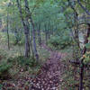
“A backwoods, multi-use trail. ”


4.1
Miles6.5
KMDoubletrack
 Difficult
Land Manager: USFS - Black Hills National Forest Office
 R.O.B.R. Ride
10.2 mi 16.4 km • 1,409' Up 429.47 m Up • 1,410' Down 429.92 m Down
 Sundance, WY
 Trail E - Carson Draw
5.2 mi 8.4 km • 605' Up 184.44 m Up • 613' Down 186.99 m Down
 Houston Creek Loop
9.1 mi 14.6 km • 1,286' Up 391.98 m Up • 1,286' Down 391.98 m Down
Carson-Cut Across-Reuter
6.4 mi 10.4 km • 1,199' Up 365.57 m Up • 1,197' Down 364.92 m Down

 Dugout Gulch Botanical Trail #77
8.6 mi 13.9 km • 1,050' Up 319.94 m Up • 1,060' Down 323.01 m Down
Beulah, WY
Gold Rush Gravel Grinder
114.8 mi 184.7 km • 6,654' Up 2028.29 m Up • 6,648' Down 2026.37 m Down
Spearfish, SD


0 Comments