
 Continue with onX Maps
 Continue with Facebook


 Intermediate

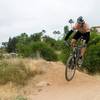
“Doubletrack dirt road with steep elevation changes. ”


10.0
Miles16.1
KMDoubletrack
 Intermediate
Local Club: San Diego Mountain/Trail & Road Bike Meetup Group
Land Manager: San Dieguito River Park
 Black Mountain Ranch West
4.8 mi 7.7 km • 297' Up 90.45 m Up • 738' Down 224.89 m Down

 Lilac Miners Peak Loop
7.8 mi 12.6 km • 1,054' Up 321.19 m Up • 1,054' Down 321.33 m Down
 San Dieguito River Park - Bernardo Bay/ Piedras Pintadas Trail
8.2 mi 13.2 km • 570' Up 173.78 m Up • 567' Down 172.96 m Down
La Costa Preserve - South Side Access
8.8 mi 14.1 km • 1,216' Up 370.54 m Up • 1,216' Down 370.49 m Down
Lake Hodges North Side
10.2 mi 16.4 km • 294' Up 89.75 m Up • 294' Down 89.75 m Down
Escondido, CA
Parking lot to E-Ticket and Back
4.6 mi 7.5 km • 530' Up 161.56 m Up • 559' Down 170.44 m Down
Santee, CA


 All Clear


1 Comment