
 Continue with onX Maps
 Continue with Facebook


 Difficult

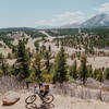
“A cardiac arresting climb leading to dreamy singletrack. ”


3.2
Miles5.1
KMSingletrack
 Difficult
Land Manager: USFS - Pike & San Isabel National Forests Office
 Monument Preserve Loop
4.9 mi 7.9 km • 556' Up 169.59 m Up • 557' Down 169.76 m Down

 Mount Herman - Limbaugh Canyon Loop
12.0 mi 19.3 km • 1,627' Up 495.94 m Up • 1,628' Down 496.11 m Down

 Greenland & Spruce Meadows Open Space Loop
19.3 mi 31.1 km • 1,270' Up 386.98 m Up • 1,271' Down 387.28 m Down
USAFA Falcon Trail
13.1 mi 21.1 km • 1,330' Up 405.49 m Up • 1,338' Down 407.75 m Down
Air For…, CO
D-Loop #2.2
7.8 mi 12.5 km • 763' Up 232.57 m Up • 786' Down 239.58 m Down
Air For…, CO
 Ute Valley Six Mile Loop
5.8 mi 9.3 km • 578' Up 176.04 m Up • 579' Down 176.35 m Down
Colorad…, CO


 Bad / Closed


2 Comments