
 Continue with onX Maps
 Continue with Facebook


 Difficult

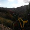
“A fun trail with a climb to an overlook, followed by a challenging descent. ”


3.8
Miles6.2
KMSingletrack
 Difficult
Land Manager: City of Pocatello, ID - Parks and Recreation
 Over The Top Loop
9.8 mi 15.8 km • 1,613' Up 491.72 m Up • 1,628' Down 496.29 m Down

 Pocatello, ID
 Lower and Upper City Creek
5.8 mi 9.3 km • 846' Up 257.71 m Up • 849' Down 258.73 m Down
Pocatello, ID
 Slate Mountain/Gibson Jack Loop
13.7 mi 22.0 km • 2,171' Up 661.8 m Up • 2,012' Down 613.38 m Down
Pocatello, ID
East Fork Crestline Classic
12.2 mi 19.6 km • 2,671' Up 814.11 m Up • 2,671' Down 813.97 m Down
Pocatello, ID


0 Comments