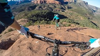
This has to be the most unique experience one can have on their bike in Sedona. The trail climbs up to a saddle bisecting two large red rock formations rising out of the canyon, then continues along a knife edge right around the side of the rock, 200 feet above the canyon floor.
It can't be stressed enough that despite the short length, this is a very serious trail. Riders should be very confident in their ability and fitness, and should be comfortable with heights!
Starting from
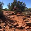
Cow Pies Trail, the trail makes its character known right away. The riding, mostly on slickrock, is very challenging, with step-ups, roll-offs, and off camber sections. The first section climbing up to the saddle isn't terribly exposed, and it's all very rideable for advanced riders, but it's enough to make you think twice in many spots. Take a break on the expansive flat saddle, eat a snack, and contemplate what's next. This is a fine place to turn around and retrace your steps if you want to get the views without the exposure that comes next.
From the saddle, the trail descends down a short section of slickrock, then becomes a dirt trail right up against the edge of the rock, which rises straight up to your left, and drops steeply down to your right. There's plenty of vegetation to the right, and it doesn't feel exactly like the edge of a cliff, but it's quite exposed. The name of the trail begins to make sense here, as the rock hangs over the trail in spots, forcing you very close to the edge.
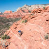
Wind around like this for a while, looking out at the views to your right when you can, and walk any sections where you're not comfortable! Eventually, the trail comes away from the edge and onto slickrock. Although you're off the edge, this is probably the most challenging, and dangerous part of the trail to ride. The trail descends steeply down the slickrock. In addition to the steepness, it drops down 3-4 foot roll-offs as it descends. With enough suspension, it's rideable, but it's so exposed that an endo feels as if it could send you tumbling for eternity. Most will choose to walk this section, which is challenging enough in bike shoes!
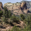
The trail becomes somewhat less exposed after this, but still quite technical until it suddenly changes to smooth and flowy through dense Junipers as it returns to
Munds Wagon Trail.

 Continue with onX Maps
 Continue with Facebook


 Very Difficult

 4.8 (23)


 All Clear


1 Comment