
 Continue with onX Maps
 Continue with Facebook


 Intermediate/Difficult


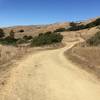
“A spicy, short and steep connector between Highway 1 and Bolinas Ridge Trail. ”


1.9
Miles3.0
KMSingletrack


4 Comments