
 Continue with onX Maps
 Continue with Facebook


 Intermediate/Difficult

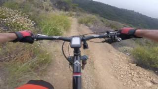
“A superb singletrack section of the Backbone Trail with a little of everything. ”


6.3
Miles10.2
KMSingletrack
 Intermediate/Difficult
Local Club: Concerned Off-Road Bicyclists Association - CORBA
Land Manager: Santa Monica Mountains National Recreation Area
 Backbone Trail: Zuma Ridge to Encincal
2.4 mi 3.9 km • 345' Up 105.29 m Up • 685' Down 208.66 m Down
 New Millennium Trail + Las Virgenes Downhill
17.2 mi 27.7 km • 2,558' Up 779.81 m Up • 2,568' Down 782.63 m Down
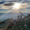
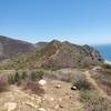
Point Mugu Loop
15.4 mi 24.7 km • 2,070' Up 631.02 m Up • 2,070' Down 630.96 m Down
 Camarillo, CA
 Dos Vientos Tour
12.2 mi 19.7 km • 1,261' Up 384.48 m Up • 1,261' Down 384.3 m Down
Rancho Canejo Open Space Loop
3.9 mi 6.3 km • 670' Up 204.18 m Up • 675' Down 205.63 m Down
Sullivan Canyon - Westridge Singletrack Loop
11.5 mi 18.6 km • 1,540' Up 469.32 m Up • 1,518' Down 462.78 m Down


 Minor Issues


0 Comments