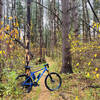
This Laurel Mt ride includes all of the best, and most challenging, mountain biking trails in this area of Forbes State Forest. Expect the majority of the trails to be rocky but with excellent flow and very little climbing. All of the trails with Expert signs were built, with the approval of the Land Manager by members of LHORBA (Laurel Highlands On & Off Road Bicycling Association).
Start this ride at the Mainline trailhead. This is located on Summit Road 2 miles off of Route 30.
Start by riding
Mainline Trail to the Warming Hut. Get on
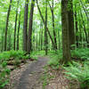
Summit Trail behind the Warming Hut. The trail will twist and turn through a tunnel of mountain laurel as you ride gradually downhill to
Spruce Run Trail.
Make a left on
Spruce Run for a fast ride surrounded by hemlocks and pines then transitioning to intermittent rock gardens. You'll cross a doubletrack with a gas well on your left. Continue straight until you come to
Burma Trail where you make a left. Follow this doubletrack back to the gas well and make a right on
Beam Run Trail.
Enjoy more rocks while keeping an eye out for the optional log piles and skinnies on your left. Make a right at T. Cross Summit Rd and make a left at the next T onto Black Bear (unmarked) for more rocky fun. At the next intersection make a right onto
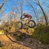
Rocky Gap. Try to clean the section of trail that squeezes through high rock walls, over roots and rocks. Bear left after coming out of the rock crevice and cross over Silvermine onto Outcrop. On Outcrop, as on all of the "Expert" trails, watch out for optional lines over numerous rock obstacles. Cross over Silvermine, ride through more rock crevices, optional log plies and skinnies before making a left on Silvermine at another gas well. Enjoy a relatively more mellow ride before making a left on Hemlock.
After a challenging short uphill burst, watch for two optional lines on your right. The second will go over two bridges followed by two skinnies. Make a right on Black Bear, a left on Silvermine, and a right on Edie Rector Road before making a left on Spruce Flats. At the 5-way intersection at the end of Spruce Flats, make the sharp right on
Wolf Rocks Trail. Gravity is mostly on your side as you pass up Wolf Rock Loop and Bobcat on your way to Wolf Rocks, where this trail ends. Park your steed here, walk out onto the huge rocks outcropping, and take in the view. This is a good place to enjoy a mid-ride snack (granola bar, PB&J sandwich, cold pork chop, etc). WARNING: In warm weather be on the look out for rattlesnakes who like to sun themselves on the rocks or in the mountain laurel).
After recharging your batteries on the rocks, retrace your route back to Wolf Rock Loop and try to clean all of the rock gardens until coming back to the 5-way intersection. Go straight on Wolf Rock Trail. As you enter a big parking lot, make a right on
Fish Run Trail. This is my favorite trail at Laurel. It will twist and turn it's way on narrow singletrack through rock gardens eventually hugging the banks of Fish Run Creek ending with a mostly 1+ mile downhill. Be careful watching for cars when the trail drops, steep and loose, onto Linn Run Road. Now the "no fun" part of the ride: make a left on Linn Run Road and ride the pavement (later turning to dirt), climbing 275' to the Laurel Ridge State Park parking lot on your left. There are restrooms here for those of you who do not want to do what the bears do.
At the far right side of main parking lot, go straight onto the
Bog Trail and then right on Picnic Trail. Enjoy the smooth fast ride to Edie Rector Rd. Make a left on the road carefully watching for Black Bear Trail on your right. Make this right and then the next right on Black Bear at the 4-way. Immediately before Black Bear spits out onto Summit Rd, make a left on the "Expert" section of Black Bear. Be aware that you'll approach a big rock that will have two options over it and you'll not see the options until you are on top of it. The right will be a skinny spanning the rocks and the left are logs filling in the crevice and this is the easier line.
Stay on Black Bear, past
Rocky Gap, and cross over Locust Camp to
Spruce Run, across Summit Rd, onto
Burma Trail. Make a left on Summit/Spruce and then a left on
Summit Trail. Cross Summit Road onto
Spruce Run. A short grunt climb then a right on Tohee. The remainder of your ride will be fast and not rocky:
Lippo's Loop, Tohee, right on Bill Albert,
Summit Trail, Main Line.

 Continue with onX Maps
 Continue with Facebook


 Difficult

 Que Trail - Full Loop

 Jerome, PA
 Jones Mills to Laurel Highlands
 Rich's Recommended Ride


1 Comment