
 Continue with onX Maps
 Continue with Facebook


 Intermediate/Difficult

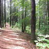
“Connects the campground to the southeastern area of the park. ”


2.1
Miles3.4
KMDoubletrack
 Intermediate/Difficult
Land Manager: NH State Parks - Parks and Rec. Dept.
 Bear Brook Beginner Loop
5.3 mi 8.5 km • 271' Up 82.67 m Up • 272' Down 82.95 m Down

 Allenst…, NH
 Rockingham Recreational Rail Trail Ride
26.3 mi 42.4 km • 303' Up 92.39 m Up • 511' Down 155.81 m Down
Spalding Park Town Forest Loop
5.3 mi 8.5 km • 454' Up 138.24 m Up • 453' Down 138.18 m Down


0 Comments