Dogs Unknown

Overview
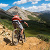
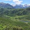
This ride is suggested as an out and back starting at the parking area located on Highway 82, up Independence Pass, east of Aspen. The ride takes you up a high alpine glaciated valley surrounded by high peaks, to a small reservoir and then continues to even higher alpine country beyond the reservoir, where you'll find some old mining era structures at the ghost town of Ruby. The riding is generally moderate with the road almost passable by 2wd car to the reservoir, with increasingly technical riding and high clearance 4wd required beyond the reservoir.
Even though this is a road, not singletrack, it's still a great climb and descent on a bike, with great views along most of the route. Turn around when you want, but the views at Ruby are astounding if you have the time to go all the way.
This is a seasonal dirt road, it is gated and closed to motor vehicles during the winter, with closure dates a little longer than the seasonal closure of Independence Pass over Highway 82. You can ride beyond the closed gate, but you'll likely find mud and snow if it is closed.
You'll notice some mega-scale water diversion projects along the road. Most of the water from this valley is collected and sent through tunnels under the continental divide towards the Arkansas River. Grab a detailed map of the area if you want to leave the road to hike up one of the side valleys
There are about 20 camp spots spread out along the first 5 miles of the road, great if you want to ride one day and do a hike in the area the next day. Or, ride one day, then pack up camp the next morning and find another ride in the Aspen area before moving on.
Description
Starting from Highway 82, you'll immediately descend alongside the Roaring Fork River for about 3/4 mile. Once you pass the group camping turn off, you're close to Lincoln Creek. You'll parallel the creek until reaching the reservoir, meaning the long climb has begun. It's rarely steep, and often flat, so the going is usually pretty easy. The road is wide but often rocky and potholed, allowing for fast speeds if you pick the right line.
Watch out for cars and trucks bumbling through the rocky potholed sections. You might be able to go much faster than the vehicles, and there are a few blind corners. After a few miles, there is a really cool section of smoothly eroded rock (right next to the road) that the creek waterfalls through. There is a dangerous cliff jump into the water below, but better check out the cool rock features than venture into the freezing water!
Once you've reached the reservoir, you can continue on the road to Ruby Ghost Town. The road gets progressively more technical and rocky with occasional water crossings and steeper sections of sustained climbing. Note that there are a couple private cabins towards the end of the road, please respect private property.
Just before the end of the road you'll find the trailhead for Anderson and Petroleum Lakes. This route used to be open to bikes, but is now closed. It's a steep but relatively short hike up to the first lake. It's worth a visit if you have the time and inclination to leave your bike behind for a little while.
As this ride is an out-and-back, you can turn around whenever your schedule demands! The return is longer and flatter than you might have thought while climbing up, but it's definitely a high speed thrill ride that will keep you smiling all the way until the very end... where you'll have to spend some time climbing back up to the pavement where you started the ride.
If you've read this far... when the gate is open, you could start your ride by driving down the initial descent, and find a pull-off parking spot that would allow you to eliminate that final climb, cutting just a couple miles off your ride.
Contacts
Shared By:
Mike Pritchard

 Continue with onX Maps
 Continue with Facebook


 Intermediate

 4.5 (16)


0 Comments