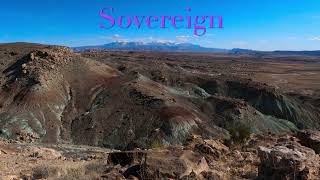
The Cedar Mountain Trail starts at an intersection just below the rim of Cedar Mountain. It covers the northeast side of the mountain and includes plenty of rocky challenging trail with awesome views. Surprisingly, it also features some tight canyons and desolate washes - a very diverse trail.
From the junction with
Sovereign stay right and climb to the rim of Cedar Mountain. The trail goes right and rolls along the edge with loose tread and amazing views. Small slot canyons along the rim create a cratered moonscape that makes the riding fun and challenging. Since this trail does see motorized traffic it has a distinct motorized flow to it.
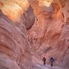
At intersection with road, the trail descends straight across through an eerie green cupric soil. At the bottom of the descent, the trail crosses the Fallen Peace Officer Trail and enters a wash. As the wash descends the canyon gets narrower and the trail gets faster. Drop your saddle and enjoy the ride!
Once you exit the wash the trail contours along the sage slopes before climbing into more technical canyon country. Multiple steep climbs, punctuated by steep descents make this section memorable.
At the next road intersection, continue to the west for a short bit before staying left and continuing with more canyons, more steeps, more fun.
The trail will eventually come to an intersection with
Sovereign and
Brushy Basin Trail. Right will take you down
Brushy Basin and back to
Dalton Wells Road and the
Sovereign trailhead near Highway 191.
Alternately, riders can stay left and follow
Sovereign along the south rim back to the steep climb (now descent!) back towards the inner trailhead on
Dalton Wells Road.
This is marked as an extension of
Sovereign trail on some maps.

 Continue with onX Maps
 Continue with Facebook


 Intermediate/Difficult


0 Comments