
 Continue with onX Maps
 Continue with Facebook


 Intermediate/Difficult

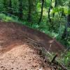
“A high speed, flowy and steep trail. ”


5.5
Miles8.8
KMSingletrack
 Intermediate/Difficult
Local Club: Disciples of Dirt (DOD)
Feb 21, 2024: Open Position
Feb 19, 2024: Whypass Cleanup: Round Three
Feb 12, 2024: Whypass Cleanup: Round Two
Land Manager: USFS - Willamette National Forest Office
 Deception Butte
4.9 mi 7.8 km • 527' Up 160.58 m Up • 2,721' Down 829.27 m Down

 Dead Mountain to Salmon Creek
15.6 mi 25.1 km • 751' Up 228.92 m Up • 3,145' Down 958.59 m Down
 2022 System Loop with Super Maple
10.6 mi 17.1 km • 1,524' Up 464.6 m Up • 1,520' Down 463.33 m Down
Springf…, OR
 Moon Point Loop
19.0 mi 30.6 km • 3,346' Up 1019.9 m Up • 3,351' Down 1021.49 m Down
Oakridge, OR
 Willamette River Trail Loop
14.2 mi 22.8 km • 129' Up 39.47 m Up • 130' Down 39.48 m Down
Eugene, OR
Middle Fork Willamette Trail #3609
31.4 mi 50.5 km • 282' Up 85.96 m Up • 4,050' Down 1234.53 m Down
Crater…, OR


0 Comments