
 Continue with onX Maps
 Continue with Facebook


 Easy
Easy

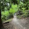
“An access corridor from Inter-garrison Road to the Fort Ord National Monument. ”


0.6
Miles1.0
KMDoubletrack
 Easy
Easy
Local Club: Monterey Off Road Cycling Association
Land Manager: BLM California - Hollister Field Office
 Pipeline Loop
9.3 mi 14.9 km • 1,616' Up 492.63 m Up • 1,616' Down 492.47 m Down

 Salinas, CA
 Road Runner to Razorback
5.2 mi 8.4 km • 702' Up 213.88 m Up • 702' Down 214.09 m Down
Best of Nisene
18.6 mi 30.0 km • 1,951' Up 594.76 m Up • 1,945' Down 592.72 m Down
Circle Loop
18.5 mi 29.8 km • 1,259' Up 383.63 m Up • 1,269' Down 386.67 m Down
Santa Cruz, CA
 Wilder Ranch Singletrack Loops
14.1 mi 22.7 km • 1,487' Up 453.27 m Up • 1,477' Down 450.15 m Down
Santa Cruz, CA
 Wilder Ranch Coast Trail
14.3 mi 23.1 km • 144' Up 43.94 m Up • 144' Down 43.9 m Down
Santa Cruz, CA


 All Clear


0 Comments