The Switzerland Trail follows the remains of a narrow gauge railroad that operated from the 1890's until 1919. The railroad once split at the town of Sunset (near the middle of the trail), where a spur line ran down Fourmile Canyon to the town of Boulder. It first served miners from Ward, Caribou, Nederland, and much of the region immediately around the trail. As mining collapsed, the trains focused on bringing tourists up for the great views and meadows (the "Switzerland" comes from marketing these day trips to tourists!). But cars become more widespread, mining dwindled, and expenses were high, so it was abandoned in 1919.
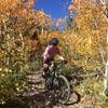
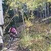
Because it was once a rail line, the grades are moderate. Some parts are a bit rocky, but much is smooth and fast. Vehicles are allowed on most sections, but traffic is very low. The scenery is sometimes stunning, with views of high peaks in all directions, aspen groves, and deep conifer forests.
Although this trail is great in either direction, many people just do sections of it as part of a larger ride. From south to north (as shown on the map):
Section 1: Highway 72 near Nederland to Sugarloaf Mountain Trailhead
This is the easiest section, with a fast downhill at first followed by nearly level grade near the end, all on very smooth surface. It's fast, fun, and has some nice scenery to the south about halfway through this section. Check out the
Sugarloaf to Gordon Gulch Loop for a good ride using this section.
Section 2: Sugarloaf Mountain Trailhead to Sunset
This part drops 1,000 feet in 4 miles, and is quite steep, rockier, and rougher than other sections. Views to the north are excellent.
Section 3: Sunset to Gold Hill Road
A long climb (over 1,000) with remarkable views and interesting history. The railroad built a hotel and park called Mt. Alto park near the top of the climb to entertain tourists long ago.
Section 4: Gold Hill Road to Lefthand Canyon
This is my favorite section, which winds through forests and eventually becomes singletrack for the last mile. It's basically flat, which is remarkable given the mountainous surroundings. It has an unglorious ending with a short hike-a-bike up to
Sawmill Road. You can actually find the continuation of this trail across the road, which has legal access for a little while longer, but then gets into private property (a real shame!), and then into hiker-only terrain.

 Continue with onX Maps
 Continue with Facebook


 Easy/Intermediate


4 Comments