Use onX Backcountry to explore the terrain in 3D, view recent satellite imagery, and more.
Now available in onX Backcountry Mobile apps!
For more information see this post.
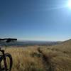
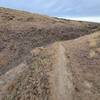
This is part of a larger network of trails known locally as State Patrol. This is the main access road at the bottom of the canyon. Almost all of the main trails running down into the canyon end at this road. This road gets VERY sandy in the summer. It can be ridden in either direction to access trails as desired.
Moderately steep. Uneven terrain with small rocks or roots.
Sizable rocks & roots. Steep sections.
Steep. Some technical terrain and limited alternate lines.
Very steep. Technical terrain with no alternate lines.
Difficulty Rating
Average from 2 votes:
Easy/Intermediate
Your Rating
Virtual Tour of Bottom Access Road
We use cookies to improve your browsing experience, to show you
personalized content, and for statistical purposes. By continuing
to navigate our website, you accept our use of cookies. Read our
Privacy Policy to learn more.

 Continue with onX Maps
 Continue with Facebook


 Easy/Intermediate


0 Comments