
 Continue with onX Maps
 Continue with Facebook


 Difficult


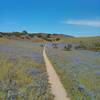
“A twisty descent on narrow singletrack along a canyon wall. ”


2.6
Miles4.1
KMSingletrack


1 Comment