MTB Project Logo

One of Aspen's premier classic trails, offering big views and challenging riding.


Your Rating: Rating Rating Rating Rating Rating      Clear Rating
Your Difficulty:
Your Favorites: Add To-Do · Your List
Zoom in to see details
Map Key

5.7

Miles

9.2

KM

Singletrack

10,075' 3,071 m

High

7,731' 2,356 m

Low

153' 47 m

Up

2,400' 731 m

Down

8%

Avg Grade (5°)

28%

Max Grade (15°)

Dogs Unknown

E-Bikes Not Allowed

Description

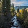
Sunnyside connects the trails of Hunter Creek and 4 Corners areas down to the paved Rio Grande bike path. The trail offers challenging riding on narrow trails, traversing and descending steep terrain while distracting you with big mountain views. Many rocky sections will test your expert level riding skills.

On the upper reaches of the trail, look out for the Shadyside Trail for optional routes and additional mileage.

The trail is adopted by the Aspen Cycling Club, which conducts annual maintenance work to keep the trail in shape.

Sunnyside is popular with hikers, especially on the lower slopes. Please yield and be polite whenever possible. Given the steep technical nature of the trail, it's recommended for downhill bike travel only.

Just before the final lowest segment of trail, you'll cross over the paved McLain Flats Rd. (parking available here). Watch out for fast vehicles before crossing over to the final segment, which links to the Rio Grande trail. Make a left to go towards Aspen.

Contacts

Shared By:

Mike Pritchard with improvements by Tim Salizzoni

Trail Ratings

  4.8 from 16 votes

#2

in Aspen

#746

Overall
  4.8 from 16 votes
5 Star
75%
4 Star
25%
3 Star
0%
2 Star
0%
1 Star
0%
Trail Rankings

#2

in Aspen

#203

in Colorado

#746

Overall
7 Views Last Month
6,265 Since Jun 9, 2013
Difficult Difficult

0%
0%
0%
0%
100%
0%

Photos

View from Red Mountain, traversing it's face on the Sunnyside trail.
Jun 8, 2013 near Aspen, CO
This is pretty mush the start of the huge descent down Sunnyside Trail.  In the distance, you can imagine where the trail traverses along the face of Red Mt. in the aspen groves, and where Shadyside Trail might be in the dark timber area.
Oct 7, 2015 near Aspen, CO
Panorama view of Red Mountain on the left (Sunnyside trail traverses through the upper aspen groves), and Aspen in the middle.
Jun 8, 2013 near Aspen, CO
Sunnyside Trail, always a worthy destination when the aspen leaves change color!
Oct 7, 2015 near Aspen, CO
Lower Sunnyside trail.  The trail turns to red rock once below the aspen groves.
Jun 8, 2013 near Aspen, CO
loading

Weather


Current Trail Conditions

Unknown
Add Your Check-In

Check-Ins

Aug 30, 2022
Oren Alexander
Jul 23, 2022
Joseph Hall
19mi — 4h 00m
Sep 18, 2021
Dylan Pradas
With Logan. Fun tech downhill. Beast of a climb to get to though. 5.7mi
Apr 23, 2021
Matthew Moodie
Muddy and glorious! 3mi
Aug 18, 2018
Jacob Schmidt
Sep 28, 2017
Nathan Baier
Jun 19, 2017
Domenic Policaro
Welcome

Join the Community

Create your FREE account today!
Already have an account? Login to close this notice.

Get Started