
 Continue with onX Maps
 Continue with Facebook


 Intermediate


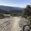
“A two mile trail along Lewis Creek through the trees. ”


2.1
Miles3.4
KMSingletrack


1 Comment