
 Continue with onX Maps
 Continue with Facebook


 Intermediate/Difficult
Intermediate/Difficult
Intermediate/Difficult
 Intermediate/Difficult
Local Club: Folsom Auburn Trail Riders Action Coalition
Land Manager: BLM California - Mother Lode Field Office
 Salmon Falls Trail to Flagstaff Hill
14.1 mi 22.7 km • 1,929' Up 588.01 m Up • 1,927' Down 587.49 m Down

 Magnolia to Cronan Loop
8.7 mi 14.0 km • 986' Up 300.48 m Up • 986' Down 300.63 m Down
Olmstead Trail
9.1 mi 14.6 km • 917' Up 279.36 m Up • 914' Down 278.57 m Down
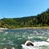
 Confluence to Maine Bar
10.3 mi 16.6 km • 1,159' Up 353.3 m Up • 1,160' Down 353.71 m Down
 Tour the ASRA
25.8 mi 41.5 km • 3,024' Up 921.73 m Up • 3,025' Down 922.06 m Down
Auburn…, CA
 Lake Natoma Loop
12.0 mi 19.3 km • 294' Up 89.75 m Up • 294' Down 89.48 m Down


 All Clear


5 Comments