
 Continue with onX Maps
 Continue with Facebook


 Difficult


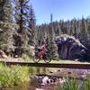
“A very technical loop from Hwy. 501 up Pajarito mountain. ”


3.2
Miles5.1
KMSingletrack


0 Comments