
 Continue with onX Maps
 Continue with Facebook


 Intermediate/Difficult

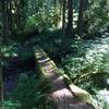
“Deep woods singletrack with old growth trees. ”


4.1
Miles6.6
KMSingletrack
 Intermediate/Difficult
Local Club: Disciples of Dirt (DOD)
Feb 21, 2024: Open Position
Feb 19, 2024: Whypass Cleanup: Round Three
Feb 12, 2024: Whypass Cleanup: Round Two
Land Manager: USFS - Willamette National Forest Office
 McKenzie River Trail (MRT)
25.4 mi 41.0 km • 488' Up 148.62 m Up • 2,197' Down 669.6 m Down

 McKenzi…, OR
A-T-C-A
McKenzi…, OR
A-T-C-A
24.1 mi 38.8 km • 3,681' Up 1121.93 m Up • 7,001' Down 2133.88 m Down
Oakridge, OR
 Pyramids Big Loop
50.4 mi 81.1 km • 11,643' Up 3548.78 m Up • 11,637' Down 3547.09 m Down
McKenzi…, OR
 Cultus Lake Loop
12.4 mi 19.9 km • 580' Up 176.91 m Up • 580' Down 176.8 m Down
South Willamette and Hardesty; No shuttle
18.2 mi 29.3 km • 4,651' Up 1417.53 m Up • 4,652' Down 1417.89 m Down
BADCAT Ultra: Mountain Bike Section
149.3 mi 240.3 km • 13,903' Up 4237.75 m Up • 13,000' Down 3962.42 m Down


 Minor Issues


0 Comments